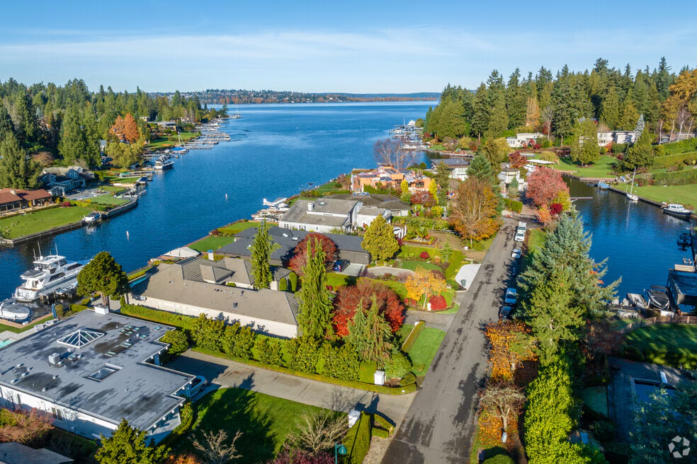
Hunts Point, Washington
Hunts Point Real Estate
A street-level look at Hunts Point, from a broker who works Hunts Point every week.
An incorporated Lake Washington town north of SR 520, with a limited number of residential parcels and decisions that are made property by property.
Hunts Point is an incorporated town, not a Medina or Bellevue neighborhood. The 2024 Census Gazetteer lists 0.307 square miles of land and 0.444 square miles of water, and the Washington Office of Financial Management estimates 455 residents as of April 1, 2026. The town incorporated in August 1955, and because official and historical sources differ on the exact day, this guide uses the month and year rather than presenting a disputed date as settled.
The current 2025 to 2045 Comprehensive Plan inventories 205 acres in the town, including 181.51 acres of single-family residential land, 16.16 acres of town rights-of-way, roughly 2.7 acres of D.K. McDonald Park, and 4.57 acres of Wetherill Nature Preserve within Hunts Point. The plan identifies R-40, R-20, and R-20A residential zones, with minimum lot sizes of 40,000, 20,000, and 12,000 square feet respectively.
For a buyer, Hunts Point is best approached as an address-specific purchase. Value can turn on the zoning district, waterfront or non-waterfront position, shoreline setback, permitted bulk, recorded plat restrictions, utility connections, and the legal status of existing improvements. On waterfront in particular, the dock, lift, covered moorage, bulkhead, and recorded agreements should be researched rather than assumed to be conforming or expandable. Colin's construction background earns its keep in exactly those places.
See the current Eastside market stats →
Citywide numbers set direction. Individual neighborhoods, streets, and waterfront segments inside Hunts Point price differently, so a map-drawn comparable analysis is the only reliable way to value a specific home.
Homes for Sale
Currently available in Hunts Point
As of September 2026 there were 1,941 active residential listings across the Eastside at 4.1 months of supply, the widest selection buyers have had in years. That means real room to compare, inspect, and negotiate.
Hunts Point turns over in small volume, and the homes that matter most often sell before the portals catch up. Rather than a stale listing grid, Colin sends a curated list of what is actually available in Hunts Point right now, including quiet, off-market, and coming-soon homes, with his read on which are priced correctly.
Read the full September 2026 Eastside market update
Looking in more than one area? Request a combined listing list
Request the current Hunts Point listing list
Every active home in Hunts Point, plus what is coming soon, sent by Colin personally. No portal spam, no lead sold to other agents.
Homes for sale
Hunts Point listings, including what is not on a portal yet
Colin tracks active, coming soon, and quietly available Hunts Point homes daily. Tell him the price range, school boundary, and must-haves and he will send the short list rather than every result.
Hunts Point Map
Hunts Point, WA 98004. Open in Google Maps
Hunts Point Market Snapshot
Data period August 15, 2025 to July 24, 2026 · rolling 12-month closed sales, refreshed semiannually
- Closed sales
- 6
- Median closed price
- $16,310,000
- Municipality
- Town of Hunts Point, King County
- Population
- 455 (2026 Washington OFM estimate)
- Land area
- 0.307 square miles
- Housing context
- 187 housing units, 191 single-family lots in the adopted plan
- Schools
- Bellevue School District, verify by address
- Public beach or boat launch
- None identified in town limits
- Short-term rentals
- Prohibited by town code
Detached homes with City = Hunts Point and Status = Sold, with recorded sale dates between August 15, 2025 and July 24, 2026. Townhomes, condominiums, co-ops, moorage, and attached records are excluded.
This is a small sample, so only the count and median are published here. No percent changes, price per square foot, days on market, price ranges, or waterfront-only medians are reported for this period. Four sales carried potential lake or waterfront flags in the underlying export, but that subset is too small and has not been verified record by record.
The right takeaway is that city-only sales volume in Hunts Point is limited. A single high-value transaction can move a median materially, so any decision should rest on property-level comparables, condition, site constraints, and current competition rather than this summary alone.
Information and statistics compiled and reported by the Northwest Multiple Listing Service. Figures describe past closed transactions in the Town of Hunts Point and are not an appraisal or a forecast.
Waterfront & Lake Washington Details
Hunts Point has private waterfront ownership with private or joint-use moorage. This page does not represent that the town provides a public Lake Washington beach, a public dock, or a public boat launch. D.K. McDonald Park is the town-owned public park. Wetherill Nature Preserve is privately held and volunteer maintained, and its pedestrian-only trails specifically offer no beach access. For an out-of-state buyer that distinction matters: private shoreline rights, shared-dock agreements, and any right to use a particular moorage facility have to be confirmed in the purchase documents, title report, recorded easements, permit file, and survey.
Hunts Point has its own Shoreline Master Program and municipal code, and it is not subject to Medina's waterfront rules. Shoreline jurisdiction includes Lake Washington, the land within 200 feet of the ordinary high-water mark, and associated wetlands. For private moorage the town generally allows one moorage facility per property, encourages joint use, limits a single-lot facility to 480 square feet of overwater area, and limits projection from the ordinary high-water mark to 100 feet on the Point. Fairweather Basin, Haug Channel, and Cozy Cove Inlet carry additional channel-width and plat-restriction limits.
The code also regulates lift placement, covered moorage, pier height, side setbacks, decking, and bulkheads. New pier skirting is prohibited, light-transmitting pier and platform-lift decking must meet the code's 40% standard, and covered moorage is capped at the lesser of 50% of the covered-moorage building zone or 1,200 square feet.
Waterfront due-diligence checklist
- Confirm the shoreline environment designation, ordinary high-water mark, setbacks, and critical-area mapping with the town
- Obtain the full town permit file for any dock, lift, covered moorage, bulkhead, clearing, grading, or shoreline work
- Determine whether a dock project would be a repair or a replacement, since the replacement analysis includes a 75% of support-piles threshold
- Measure the actual facility against current limits for overwater coverage, length, width, side setbacks, lift placement, and covered moorage
- Review recorded plats, surveys, covenants, and easements, since plat restrictions in Fairweather Basin, Haug Channel, and Cozy Cove Inlet can affect dock length
- Confirm whether a shared facility has a recorded King County agreement covering use and maintenance
- Ask whether an improvement sits over state-owned aquatic land, then obtain the Washington DNR authorization, term, and payment obligation
- Request prior in-water approvals from the town, Washington Department of Fish and Wildlife, and the U.S. Army Corps of Engineers
- Verify flood information for the exact parcel through FEMA's Flood Map Service Center and King County floodplain resources
- Confirm whether the property is subject to the town's tree-removal permit requirements before planning site work
Parks, Trails & Everyday Recreation
D.K. McDonald Park is the town's roughly 2.7-acre public park. Its features include Town Hall, a playground, a fenced sport court, an open playfield, a crushed-rock walking trail, and a pedestrian connection to the Points Loop Trail and the SR 520 Trail.
Wetherill Nature Preserve is a separate private preserve shared by the Hunts Point and Yarrow Point communities and maintained through volunteer effort. It is open during daylight hours for pedestrian trail use, and it is not a public beach-access amenity.
The Points Loop Trail connects Hunts Point with Medina, Yarrow Point, and Clyde Hill, and the SR 520 Regional Trail adds a broader regional connection. Trail, crossing, and sidewalk conditions vary by route and address, so walking the route from a specific address is still worth the time when trail use matters to the decision.
Public and shared open space
- D.K. McDonald Park: about 2.7 acres, Town Hall, playground, sport court, playfield, walking trail
- Wetherill Nature Preserve: private, volunteer maintained, pedestrian trails, no beach access
- Points Loop Trail through Medina, Yarrow Point, and Clyde Hill
- SR 520 Regional Trail and the SR 520 lid open space
- No town-owned public beach, public dock, or boat launch identified in town limits
Schools, Transit & Travel Planning
Hunts Point is served by the Bellevue School District, which assigns students based on the residence address. There are no schools inside the Town of Hunts Point. For a specific property, verify the current assignment through the district's WebQuery School Locator. Attendance areas, transportation eligibility, choice programs, and enrollment policies can change, and nothing here represents school quality, ratings, or the assignment for a particular address.
There is no transit stop inside town limits. The town's plan identifies the Evergreen Point Freeway Station about 0.5 miles west in Medina and the Yarrow Point Freeway Station about 0.6 miles east in Clyde Hill, both reachable via the Points Loop Trail and the regional bike corridor. Route availability and service changes should be checked with King County Metro and Sound Transit.
SR 520 is the primary regional connection. It is tolled in both directions, rates vary by time of day, and WSDOT publishes current rates and payment methods. The town's plan also notes that the primary roundabout is the only entrance and exit for most residents, which is a practical consideration during peak periods and incidents. Colin does not publish fixed commute-time promises: travel varies by hour, direction, weather, incidents, and construction, and the SR 520 Portage Bay Bridge and Roanoke Lid project continues through 2031 on the Seattle-bound approach.
Verify before you commit
- Run the exact address through the Bellevue School District WebQuery School Locator
- Reconfirm assignment before contingencies come off, since boundaries change
- Check current King County Metro and Sound Transit service at the Evergreen Point and Yarrow Point freeway stations
- Review current SR 520 toll rates and payment methods with WSDOT
- Test the drive at your real departure time, both directions, through the single roundabout entrance
Zoning, Construction & Buyer Research
The town adopted its 2025 to 2045 Comprehensive Plan on July 7, 2025. The plan describes 16 lots as potentially subdividable into as many as 19 new single-family lots, subject to actual review and applicable requirements. It also describes an intention to adopt a future middle-housing chapter for specified R-20A lots near 84th Avenue transit stops. Treat that as a pending policy direction rather than a current entitlement unless the town confirms the implementing code is in effect.
Hunts Point restricts the primary permitted use of property in all zones to single-family residential purposes, and its code states that short-term rentals are not allowed. That is material if you are considering a part-year residence or a rental-income strategy.
The town's permit-packet page, Shoreline Master Program, municipal code, and public-records request process are the right starting points for a property-specific due-diligence file. Colin runs this material on any home a client is serious about, and refreshes this page on a semiannual cadence using the trailing 12 months of city-only closed sales. When a segment has five to nine sales, only the count and median are published with a small-sample notice, and everything is suppressed below five sales.
Research a Specific Address
- Town of Hunts PointTown government, services, and current notices
- Hunts Point 2025 zoning mapR-40, R-20, and R-20A districts
- Hunts Point critical-area mapsCritical areas mapped by the town
- Hunts Point Shoreline Master ProgramShoreline jurisdiction, moorage, and dock standards
- Hunts Point Municipal Code, Chapter 18.40Piers, lifts, covered moorage, decking, and bulkheads
- Hunts Point Municipal Code, Chapter 18.20Single-family use and the short-term rental prohibition
- Hunts Point Comprehensive Plan 2025 to 2045Land inventory, zoning policy, parks, and transportation
- Hunts Point permit packetsPermit forms and submittal requirements
- Hunts Point public-records requestsHow to request permit history and town records
- Bellevue School District school locatorAddress-based school assignment lookup
- King County Parcel ViewerParcel boundaries, dimensions, and property records
- King County iMapZoning, shoreline, critical area, and utility layers
- FEMA Flood Map Service CenterEffective flood map for the exact parcel
- King County floodplain resourcesCounty flood hazard mapping and guidance
- WSDOT SR 520 tollingCurrent toll rates and payment methods
Public maps and records are a starting point, not a substitute for a survey, title review, shoreline determination, school assignment confirmation, or permit verification. Ask Colin to run the address for you.
Hunts Point Real Estate Questions
No. Hunts Point is its own incorporated town with its own code, zoning map, and shoreline regulations. It contracts with neighboring jurisdictions for some services, including police from Medina and fire, water, and wastewater service from Bellevue.
The town does not identify a town-owned public beach, public dock, or boat launch. D.K. McDonald Park is the town-owned park, and the trails at Wetherill Nature Preserve specifically offer no beach access.
Possibly, but feasibility is property specific. The town generally allows one moorage facility per property, limits a single-lot facility to 480 square feet of overwater area, and limits projection to 100 feet from the ordinary high-water mark on the Point. Plat restrictions in Fairweather Basin, Haug Channel, and Cozy Cove Inlet can further limit length. Start with the permit file, the Shoreline Master Program, and a conversation with the town.
The current city-only snapshot shows six detached-home sales over the trailing 12 months with a median closed price of $16,310,000. With that few transactions, one sale can move the median, so treat the figure as context and ask Colin for the comparables on your specific stretch of shore.
Because the sample is small. With six closed sales and roughly 187 housing units in town, percent changes, price per square foot, days on market, and waterfront-only medians would imply a precision the data does not support. When a segment has five to nine sales, Colin publishes only the count and median, and suppresses figures entirely below five.
No. The town's zoning code states that no short-term rentals are allowed, which is material if you are considering a part-year residence or a rental-income strategy.
Hunts Point is served by the Bellevue School District, and there are no schools inside town limits. Use the district's WebQuery School Locator to confirm the current assignment for a specific address, and reconfirm before contingencies come off.
The adopted plan identifies R-40, R-20, and R-20A residential zones, with minimum lot sizes of 40,000, 20,000, and 12,000 square feet respectively. Confirm the district and current standards for a specific parcel with the town before planning a remodel or a rebuild.
The 2025 to 2045 Comprehensive Plan describes 16 lots as potentially subdividable into up to 19 new single-family lots, subject to actual review and applicable requirements. The plan also describes a possible future middle-housing chapter for certain R-20A lots near 84th Avenue transit stops. Treat that as pending policy, not a current entitlement.
The King County Flood Insurance Study reviewed for this guide reports no Special Flood Hazard Areas identified in Hunts Point, but the retrieved study carries a preliminary label. That is not a conclusion of no flood risk. Confirm the effective map and parcel-specific information through FEMA's Flood Map Service Center and King County floodplain resources.
SR 520 is the primary regional connection and is tolled in both directions. There is no transit stop in town, though the Evergreen Point Freeway Station in Medina and the Yarrow Point Freeway Station in Clyde Hill are roughly half a mile away. The town's plan notes that the primary roundabout is the only entrance and exit for most residents, which matters at peak times.
Start with the town's zoning and critical-area maps, the permit history, the recorded plat and survey, a current title report, and a property-specific conversation with the town. For waterfront lots, add shoreline, DNR, WDFW, and Army Corps documentation to the due-diligence file.
Semiannually, using the trailing 12 months of city-only closed sales, with detached and attached property types kept separate. Ask Colin for the live picture of active inventory and pending sales, which a closed-sales snapshot cannot show.
Hunts Point suits buyers who want a Hunts Point address with an established residential setting. Whether it fits you comes down to the specific street: grade, traffic pattern, school assignment, outlook, and how far you actually walk or drive for daily errands. Colin will walk a shortlist of Hunts Point addresses with you in the traffic and daylight conditions that match your real routine before you commit.
It depends on the property. Parts of Hunts Point are platted without any association, while newer plats, townhome communities, condominiums, and shoreline or recreation communities can carry dues, rules, and reserve obligations. Never assume from the listing remarks: request the recorded covenants, current budget and reserve study, meeting minutes, insurance certificate, and any special assessment history, then read them before your contingency expires.
Walkability here is address-specific. Some streets sit within an easy flat walk of a park, trail connection, or small commercial node, and others involve steep grade, missing sidewalk segments, or an arterial crossing. Walk the route you would actually use, at the time of day you would use it, before you decide.
Inventory in Hunts Point spans multiple build eras, so systems, layouts, ceiling heights, energy performance, and lot usability differ widely between homes that look similar online. Colin's construction background is most valuable here: he reads drainage, foundation, roof life, and unpermitted additions during the first showing, well before the inspection contingency puts you on a clock.
Families are a large share of buyers in Hunts Point, drawn by Bellevue School District schools, nearby parks, and quiet residential streets. The details that matter most in practice are the assigned schools for the specific address, the walking or bus route to them, traffic on the street itself, and usable yard space on a sloped lot. Those are all verifiable before you write an offer.
Keep Exploring
Neighborhoods near Hunts Point
Part of Medina.
Neighborhood
Clyde Hill
Understand what living in Clyde Hill is actually like street by street, inside the wider Medina market.
Neighborhood
Yarrow Point
Understand what living in Yarrow Point is actually like street by street, inside the wider Medina market.
Guide
Neighborhood Comparison
Compare Eastside neighborhoods side by side on price, schools, and commute before picking one.
Looking at Hunts Point specifically?
Colin will tell you which Hunts Point streets are worth your time and which are not, before you spend a Saturday on them.